Jogging along the County Road--the saga of the first survey of Tiny By Jack Ellis
Driving along the sweeping curves of County Road 6 through Tiny Township is always a pleasure, especially when the sun is out, the berries are ripe and the corn in bloom. Much of the driving pleasure arises because the road is not dead straight, but takes a left bend here, a swoop to the right there. All of these jogs in the road lend interest to the drive and break up what would otherwise be the boredom of straight ahead motoring.
Did you ever wonder why the County Road has such impressive bends, and why they occur between some concession roads but not others? As a small boy in the 1940s and early 1950s being driven once a summer to the cottage near Concession 12, I wondered too, because in those days, the bends in the road were not the graceful sweeping curves of today, but sharp right-angled corners passing close between fences and hedgerows of piled stones. You can still see the remnants of the old route in some places today, such as between Concessions 11 and 12. My dad's trusty 1936 Ford had none-too-powerful mechanical brakes, and we had to slow right down to get around those bends or else risk a trip straight into the next cornfield! In the 1960s and 1970s the sharp bends were widened and straightened to make today's gentle speed-limit curves, but it wasn't until I was a middle-aged man in the 1990s that I finally found out why we all go "jogging" along the County Road.
The story starts back in the early part of the 19th century. At that time, the land which would become Tiny Township had recently become part of Upper Canada, after the British Crown concluded a purchase agreement with the native Indians. The revolt leading to independence of the American colonies was then fresh in the memory of all in Upper Canada, as Ontario was known at the time. After the conclusion of the Napoleonic Wars in Europe and the British-American War of 1812, there were significant influxes of population from the old, now economically depressed, states of Europe and the new, now self possessed but vengeful, United States of America. Although there were sizeable numbers of Upper Canadians who left for the U.S., the population of Upper Canada doubled to about 200,000 in the first couple of decades of the 1800s.
The colonial government of Upper Canada had to take swift action to ensure that all these new settlers could make a living, and the majority had to find this on the land. Agriculture was the way of life that most of the incoming settlers knew, and plentiful free or cheap land was the attraction for them to come to the frontier in Upper Canada. Accordingly, the government busily engaged surveyors to lay out settlement roads with settlement lots located along their length. Up to 1818, this was a gradual affair and the surveyors were paid 10 shillings per day for their work, a goodly sum at the time. But as pressures for more settlement mounted, the work had to be done faster. Also, the government faced a cash flow problem from absorbing so many people while giving the land away free. It therefore introduced two major innovations that changed the surveying process to make it faster and more economical for the government.
The first innovation was to pay the surveyors in land rather than cash. The new method of payment for the surveyor undertaking the daunting task of carving a whole township out of the bush was to grant him 5 1/2% of the land he surveyed. He even got to choose which lots he wanted for himself, and he could sell the land without clearing it or settling on it as new owners normally had to do. This solved the government's problems of cash outlays and surveyors taking their own sweet time to do the work, but it introduced the new problem of surveyors rushing to cover as much ground as they could in the shortest time possible, thus increasing the likelihood of errors arising from sloppy surveying. It also had the effect of downloading the cash flow problem onto the surveyor, since he needed to hire the standard 6-man crew, provision them for several months, pay them also in land, and then wait for quite some time to receive his land, and then to turn it into cash. This was pretty hard to do while the government was still giving land away free. The merchants who extended credit for the supplies may have made more money out of a survey than the surveyor did himself!
The second innovation was to lay out the townships in a "double front" system. Previous surveys laid out lots with a surveyed road allowance on both their front and back sides. The new method involved laying out concessions with two 100 acre parcels of land between them, thereby reducing the time needed for the survey. This change meant that there would normally be a lot boundary in the middle of each concession. It turns out that that is just where we find the jogs today in County Road 6. For the reason why, read on.
The government official in charge of laying out the townships for settlement was the Surveyor General, in those times a most important personage. In the period just before and after 1820, this was one Mr. Thomas Ridout. He had to find competent surveyors willing to go off into virgin land and survey deep bush and swamps for months at a time and wait ages for their payoff. In 1812, Samuel Wilmot had laid out the Penetanguishene Road from the head of Kempenfeldt Bay to Penetanguishene, where the Naval and Military Establishments were situated to defend against the invading Americans. This road had two concessions (of unequal depth) containing settlement lots on either side of it. These are referred to nowadays as the "Old Survey Concessions". (Tiny Township contained the 1st and 2nd Old Survey Concessions west of the Penetanguishene Road until 1995, when they were gifted to Midland in the Simcoe County restructuring.) In 1820, Medonte and Vespra Townships already had been laid out. Tiny and Flos were slated to be next, and Mr. Ridout began casting about for a surveyor to conduct the surveys of both Townships.
The act of performing the first survey of a township in the early 1800s had significant administrative implications. Prior to being surveyed into lots, the land was considered "waste lands of the Crown", and obtaining legal title was an uncertain process. Once surveyed, legal title to the lands could be easily recorded, and local government set up.
After some deliberation (some might say, desperation), Mr. Ridout gave the surveying contract for Tiny and Flos to one John Goessman, a newly-qualified Deputy Surveyor. John Goessman was born in the town of Osnabruck in the Electorate of Hannover (now part of the Federal Republic of Germany, of course). Since Hannover's royal family had provided kings who took the British throne, it enjoyed good relations with the British and their colonies. Goessman arrived in Upper Canada as a young man some time in 1819. He apparently had been educated as a surveyor, but still needed to obtain the necessary qualifications to deem him a Deputy Surveyor in Upper Canada, which made one eligible to conduct official survey work. In December, 1820, he finally got his papers. Meanwhile, he had been negotiating with Ridout for work, and by the Spring of 1821 had reached a verbal agreement to get the contract to survey Flos and Tiny.
On August 18, 1821, just a few short months after becoming qualified, Goessman received the formal Instructions from Ridout which officially enabled him to proceed with the survey. "Agreeable to your contract you will proceed with as little delay as possible on receipt of these instructions and survey and lay out according to the principle of the Diagram Plan herewith sent you the Townships of Flos and Tiny in the Home District..."
Goessman kept a detailed diary covering the events of each day he was involved in the survey. He recorded events in nature and the human foibles of his crew in addition to telling us exactly what progress the survey work had made that day. The diary reveals a person who seemed psychologically ill prepared to face the difficulties of a bush survey on the frontier. He comes across as an educated gentleman forced to deal with surly and uneducated frontiersmen. He always shows respect for men he deems to be of his own calibre, although that same feeling often seems not to have been reciprocated. All in all, his dairy makes absolutely fascinating reading for anyone interested in frontier conditions in Upper Canada, and it is kept to this day in the Survey Records section of the Ministry of Natural Resources, under the number D-497. In the following quotations excerpted from the diary, I have copied the words from his original diary with mis-spellings and all, to give you the flavour of the document and the times in which it was written.
Goessman records his departure from York on the afternoon of the 24th of September, 1821. He set out for Newmarket, where he had arranged for a merchant named Peter Robinson to furnish men and supplies for the survey. Delays started right at the outset, and even when things got going, there were shortages. On September 29th he complains: "The men returned with a scanty supply of furniture: viz. Kettle without cover, no dipper, etc. In the forenoon I set out and proceeded till Mr. Gill on Grasses Point in Innisfil."
Not until October 1st did he manage to cross the portage from Kempenfeldt Bay to the Nottawasaga River, then used as the "highway" to reach Nottawasaga Bay. His men were surly, and he both scolded them and bribed them with liquor, a factor which was to lead to frequent drunken binges by his crew. On October 2nd he wrote: "The men gave me rude language; which I had suspected since I left Newmarket . . . I firmly requested of them to declare their resolution instantly. Either to perform the requisite Duty or to venture the consequences of desisting from their engagement. They then declared for the former and I assigned them for the future a proper allowance of whisky. . . "
Finally he got his crew onto the survey of Flos by October 4th, but problems never seemed to cease! (Oct. 9th) "I & Hasseth remained the night in our Encampment: the others returned to Peter Robinson Esq's. Storehouse: I then told them that I requested them now to stay there till I might go & return to the head of the Natawaysawga Storehouse - in case they would obey my request, and on the contrary they should be exposed to the utmost rigour of Law" (Oct. 11th) "We mended the canoe & took in a new supply of Provision . . . About 4 miles from the Store at the Head we met Peter Robinson's Batteaux & on board thereof all the men of my surveying party. I ordered James Radclif & James Long to return with me & as they refused I requested the Blankets which I had expended to them . . " (Oct. 13th) "I gave direction to Peter Robinson Esq's. Storekeeper to engage an other party. . . mended the Compass whereon the Glass was broke, I put a new Glass thereon which I cut out of a paine of Window Glass by the help of a hot fire. . ."
After so much frustration with the men supplied by Peter Robinson of Newmarket, Goessman broke off the survey for a few days and went to Penetanguishene where he arranged for a merchant named George McCarty to supply men and provisions. But this new arrangement also went sour: (Nov. 9th) "The men whom Mr. George McCarty had sent for a recompletion of the Party absconded again . . . I examined the chaining of the West Boundary . . but found it to be so imperfect that I shall have to chain this Boundary over again . . ."
By November 12th, heavy snows were starting to fall, and the survey work was slowed even more. This caused the crew to run out of provisions and they often set out for the storehouse without permission. Goessman raised lots of trouble at the storehouse, and there he was even arrested by drunken soldiers at what is now Wasaga Beach. He wrote letters of complaint about this to various high authorities, to no avail, over the course of the next five years: (Nov. 24th) "I was seized by a Detachment of Soldiers under command of Mr. Bennetts, & cruelly treated, & compelled by them to give them the liberty at the Liquor I had at the Store of my Surveying Party." (Nov. 25th) "The Soldiers, under Mr. Bennetts command still continued their cruelty & no doubt Mr. Bennetts would have remained there with his Soldiers as long as my Liquor would have continued if not Mr. Eli Beaman had arrived of Penetanguishene who procured me security for my things & took me with him in his room. Mr. Bennetts departed early with his Soldiers. He proposed me a Passage with him in the boat to Penetanguishene which I on account of the conduct he had exercised prudently rejected; but send my Baggage with, merely on account of being almost uncapable of carrying it in consequence of the abuses I had been exposed to by his detachment." (Dec. 1st, in Penetanguishene) "I handed a letter of complaint against Mr. Bennetts to Capt. Roberts, by his servant in his house, waited a while for answer at first there & then at Mr. George McCartys house. But receiving no answer & being hailed by the Soldiers in the same cruel Language they used at the mouth of the Natawaysawga, I was obliged to leave the Establishment without receiving an answer."
After all these troubles, Goessman wrote to Ridout saying he had completed the survey of Flos on November 27th, 1821. During the winter months of 1822, he started to draw up his plan of survey and put his notes in order for Ridout to approve.
Despite the troubles and turmoil encountered in Flos, Goessman seemed amazingly eager to start the much larger job of surveying Tiny Township. By February 17th, 1822, he showed up in Penetanguishene, long before Mr. McCarty was ready for him. His diary records for each day to the middle of March how impatient he was waiting arond. He used the time to write a letter of complaint about the soldiers to the Lieutenant Governor of Upper Canada, Sir Peregine Maitland. He did some drafting work for Lieutenant Henry Bayfield of the Royal Navy, and tried to get local surveying jobs. On March 17th, McCarty finally set out for Newmarket to engage men for Goessman's crew, leaving Goessman to mind his house until the 25th. Finally Goessman started surveying on March 31st, but with only four men instead of the desired six: (March 31st) ". . . I had to advance the best I could with these 4 men as Mr. McCarty justifyed himself that he had not more employed, which he founded upon an Information he had obtained respecting the number of men necessary required to a Surveying Party. Probably of Mr. Samuel Richardson, according to which that 6 men were requisite, where I requested 7 men & besides 1 man to carry my things."
Even well into April, the winter of 1822 was severe. On April 5th, Goessman records crossing Thunder Bay on the ice. He notes many snowy days, with April 10th being so bad they had to stay in camp. Unfortunately, the men had a 10 day supply of liquor with them at the time, which they used to get royally intoxicated. Along the shore, which Goessman was instructed to survey as the boundary of the westernmost lots in Tiny, the conditions were so bad it was hard to tell where the land ended and the water began: (April 20th) " . . . Untill the 18th the Ground has been complete covered with snow from the winter. The bays of Lake Huron were till then covered with ice as far as the eye could distinguish, & did near the shore bear, but was dangerous. We run a line on the 18th on the ice. . ."
Through April, May and June, Goessman had repeated problems with men deserting him or getting too drunk to work. He also had trouble getting provisions, and spoiled beef had to be thrown away more than once. He records several trips, some in vain, to the mouth of the Nottawasaga River to collect his stores of provisions. There Goessman again had to reckon with his old nemesis, Mr. Bennetts, whom he accused of pilfering his supplies and being too friendly with his crew. (June 12th) "William Cawin & Leander Valleur had returned but little of that poor lean Beef - we therefore were now short on Provision, on account of which I in the intermedia time went a little up the river to get a few fish . . I also let them have a little of my Whisky . . . - when I returned they were altogether intoxicated . . . I immediately took all the Whisky away. . . " (June 14th) "Mr. Sutherland, Peter Robinson Esq's Storekeeper, refused to lend, sell or let me have on account of Mr. George McCarty any Provision. But in the contrary treated my men with whisky so as to keep them drunk. The men consequently refused to work, on which he delightful smiled, untill almost noon were we detained, and when we came at the Place to begin Leander & Brown run off - for to go to the Establishment to get more whisky."
By the latter part of June, the men were becoming even more insubordinate, and Goessman almost gave up the job. His men assaulted him. He even was arrested for supposedly not having paid for his surveying instruments! (June 19th) "We only began to run again by 4 P.M. . . when the men now actually disobeyed my orders . . ." (June 23rd) ". . . on account of having no full supply for Dinner, the men, especially W. Cawin, refused and run off to the Establishment. I now went to the establishment & declared to Mr. G. McCarty firmly my intention to abandone the Survey & put the Law in force against them . . ." (July 2nd) " . . . it was now evident that the men were in no way of Such character whereon the least confidence could be placed . . . W. Ducks & L. Valleur became entirely unfit for their Duty in consequence of a keg with whisky which Leander Valleur had with him. . . Leander Valleur in his drunkenness attempted an assault on me & I was guarded against him by Reed & Robinson." (July 15th) " . . .Valleur conducted himself very raskaly today, neither did he respect my own property but took of them by force whatever he could get ahold of . . ." (July 27th) " . . . Mr Johnson snatched away my compass & Staff, producing a false account against Mr. Roe, trader of Newmarket, & requested the account thereof to be answered by me. I being sensible of the falsehood of said Bill . . . engaged to procure the arrangement of their false bill when I should come to Newmarket. I then set out in my canoe to cross the Lake but when I was on the way . . . I was met by Messrs. Wymars & Brown with the packet boat, who shewed me a Warrant prosecuting me of Robbery. Whereupon I requested them to do their Duty, & accordingly they carried me bak on their vessel & took me prisoner."
Near the end of the work a most unpleasant incident occurred, along with other problems: (August 29th) " . . . When I was proceeded a little on the Line, I went a little distance from the Line, placing my Breakfast upon the compass. But by returning I found human excrement placed with my victuals together on the compass: for which I have reasonable excuse to suspect it was Brown. I went off immediately - especially for fear of a more cruel usage by Brown. The compass by washing it proved to be damaged. . . " (August 31st) " . . . Mr. G. McCarty was very vulgar to me, & took my instruments from me, damaged the compass & squeezed me my hand so much that it hindered me in writing the other morning. All in consequence of me rejecting Brown on account of his conduct." (Sept. 4th) " . . . I finished the Survey. . . I treated the men & then discharged them. . . Since the time when the Dirt was put on my Instrument . . . I had to cook my own victuals, make my own encampment, as I impossible could eat with such a party that shewed such a low conduct as to rake with their hands in human excrement."
Grumbling and complaining to the end, Goessman finally finished up his notes and plans of the survey in January, 1823, delivering them to the Surveyor General after receiving letters telling him to hurry up with their submission. Thomas Ridout officially accepted the survey on behalf of the Crown, and Tiny and Flos came into existence. Goessman was quickly given patents to the lots which he had selected as his payment, amounting to almost 6,000 acres of land in Tiny. Incidentally, the patents describing Goessman's broken lots on the shore make it totally clear that the concession roads and lots extended, and the lots were granted, to the water's edge, a point which was to become obfuscated in numerous legal and administrative actions over the following 170 years.
Before we can go on to solve the mystery of the "jogs" in the County Road, we must consider not just the human dynamics and harsh weather conditions of the survey, just described, but also the surveying technology of the 1820s.
While we now have global positioning satellites to pinpoint our position anywhere on earth, and laser rangefinders and measuring devices that give surveys an unprecedented degree of accuracy, Goessman did not even have a theodolite, commonly known as a transit, which had then just been invented. He used a horizontal compass for measuring angles and keeping his survey lines straight, and a standard chain for measuring distances. The "chain" was also a unit of measurement, 66 feet in length. The surveyor's chain was actually made of 100 links of heavy wire so that fractions of a chain were easy to measure by just counting the links. The compass was a simple magnetic one, typically about 5 inches in diameter. If well cared for and properly used, it could measure angles to an accuracy of about 1/2 of a degree.
The first step in laying out the double-front survey of Tiny was to mark out the Baseline, parallel to the Old Penetanguishene Road. This road runs inland parallel to County Road 6, and still can be driven for much of its length. It runs fairly straight, since Goessman surveyed its whole length. Then he had to lay out concessions at right angles to the Baseline, each measuring 66 2/3 chains in width, separated by a road allowance 1 chain wide. Between every five lots from the Baseline to the shore, a 1 chain allowance was marked out for a road along the sides of the lots, though the surveyor was not expected to ever open these sideroads or check their alignment. The sideroad allowance Goessman marked out between lots 13 and 14 formed the initial corridor for what is now County Road 6. Along the concession road allowances, the lots were to measure 30 chains in frontage, thus making full lots measuring 30 x 66 2/3 chains, or 200 acres. The government's normal practice was to grant settlers half-lots of 100 acres, in Tiny's case north and south half lots, each fronting on a different concession.
The surveyor was required to place a wooden marker, branded and numbered with a hot iron, in the centre of the concession road allowance where each lot boundary occurred, along with two markers at either side of the road allowance to delineate the corner points of the half-lots. The survey party first blazed a trail through the woods along the centreline of the concession road allowance so they could see where they were going. The compass was used to keep the trail as straight as possible. Then the lots were laid out from the Baseline to the shore, or vice versa, using the compass to keep in line, by laying the chain down 30 times (supposedly) for each lot.
All this sounds deceptively simple, but there were many problems. First, consider the compass. Although not normally considered a delicate instrument, the diary shows that Goessman's compass fairly often got smashed and he could only fix it in the crudest of manners. In fact, the diary mentions seven different occasions when the compass needed repair. If the direction of a concession road as measured by the surveyor's compass was off line, or if he inadvertently changed direction part of the way along, significant errors could arise. For example, the concession road between concessions 6 and 7 was re-surveyed in 1891 to establish the true lot boundaries. The portion of the concession road between the Baseline and County Road 6 differs in direction from the rest of the concession road out to the water's edge by 2 degrees and 11 minutes. That may not sound like much, but this amount of error in alignment over the distance of 5 lot widths (intended to be 150 chains or about 9,900 feet) can cause the location of the end-point to be in the wrong place by over 390 feet! (Modern surveyors expect to be accurate within one foot or less after 10,000 feet.)
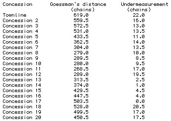
Now we should also consider the chain. Although it was a very simple and sturdy field implement, it had to be used correctly. Measurement errors could creep into the survey if the chain were not pulled straight for each measurement, if some links became tangled with each other or with brush, and no compensation for chaining up or down slopes was used. But Goessman's most common error seems to be under-measurement, probably arising from simple mis-counting while chaining. Modern day measurements of actual distances in Tiny are almost always found to be somewhat greater than what Goessman recorded. Perhaps he or his men frequently lost count or would forget to add "one" when moving the chain along. To check on Goessman's accuracy, David Lambden, Professor of Surveying of the University of Toronto, in 1993 compared Goessman's measurements to the actual distances for the 20 concession roads that extend from the Baseline west to the shore. He found that Goessman had measured the correct distance in only one instance (for concession 16/17). The actual distances for the 19 others were greater than Goessman recorded, with discrepancies ranging from 1 chain to 22 chains, or from 66 feet up to 1,452 feet! The result was that some lucky future owners got an extra chain or more in the width of their lot than the 30 chains they expected!
Now we come to the solution of the "mysterious" jogs and curves in County Road 6. As noted above, County Road 6 was laid out as a sideroad in the survey. It was never surveyed for its own alignment, but had to take its position from the markers, 1 chain apart, that Goessman placed along each concession road allowance between lots 13 and 14. But as Goessman went up and down the concessions marking out lots, unbeknownst to him, his chained measurements often were not only wrong, but usually didn't agree from one concession to another. Prof. Lambden found, for instance, an error in the distance run on the Concession 11 road of 19.5 chains, or 1,287 feet. But on Concession 12, the error is "only" 2.5 chains, or 165 feet. This difference in errors is over 1,100 feet, and it means that on these adjacent concession roads the north and south half-lots could be out of alignment by as much as 1,100 feet! If, about halfway down the concession roads, about where County Road 6 runs, perhaps half of this error had occurred, this would lead to a sideways "jog" of about 550 feet.
Such jogs in the road occur, then, wherever the difference in Goessman's measuring errors on adjacent concessions is appreciable, and the jogs always occur in mid-concession. (There is one exception to this latter rule on County Road 6. Can you spot it, and suggest the reason why it occurs where it does?) The amount of the jog sideways is proportional to the difference in measurement errors, and the direction should be either towards or away from the Baseline depending on which concession road has the greater error. For example, when you enter Perkinsfield from the south, you cross Concession 9. Its error of measurement is 8.5 chains. Heading toward the main corner (Concession 10) there is a gentle bend with a displacement of maybe 40 or 50 feet towards the water. That bend arises because Concession road 10 has an error of measurement of 9.5 chains, 1 chain greater than Concession 9; i.e., actual distances along it are farther from the Baseline. Heading out of Perkinsfield to the next concession, we swoop towards the water in a major way. That is because Concession 11 has a measuring error of 17 chains, greater by 7.5 chains or 495 feet than the error in Concession 10. Then we swoop a bit inland before Concession 12, which has a measuring error of 19.5 chains. Hey, shouldn't that swoop be toward the lake, because the error in distance from the baseline to the lake is 2.5 chains greater? Yes, but Goessman apparently didn't always make his errors in equal intervals along the concession lines. In this particular case, it would seem that he made greater errors in chaining from the Baseline out to the County Road than he did in going the rest of the way to the lake.
Going north again, we take a big jog inland before Concession 13, which has a measuring error of only 2.5 chains. And so on and so forth. Maybe you parents can make up a game of "spot the short chainage" as you drive the children along County Road 6, as a change from answering the endless question of "when will we get there, Daddy?" To help you, the following table is presented courtesy of Prof. David Lambden. As you drive them along County Road 6, see if your kids can use it to predict how much of a jog will occur in the road and in which direction, and see if the simple prediction agrees with present day reality. (It might not, as I showed for the jog between Concessions 11 and 12.)
Comparison of Goessman's measurements from the Baseline to the shore along Concessions
So now you have the answer to one of Tiny's "historical mysteries", one that we all encounter every time we drive through Tiny!
As a post-script to the saga of the survey, history tells us that the payment of surveyors was changed back to a cash basis in 1827. John Goessman continued to be active as a surveyor in Upper Canada, but he never received another township survey assignment. In 1835, the Surveyor General even fired him from a job doing a partial survey of Vespra. Contemporary letters make such remarks as "Mr. Goessman is much imposed on by his men." In 1857, Goessman died, remaining a licensed surveyor to the end.
Watch this space in future issues for more articles highlighting a feature of Tiny Township's fascinating history! Let us know if you enjoyed this one, and send us suggestions on what you would like to read about next.